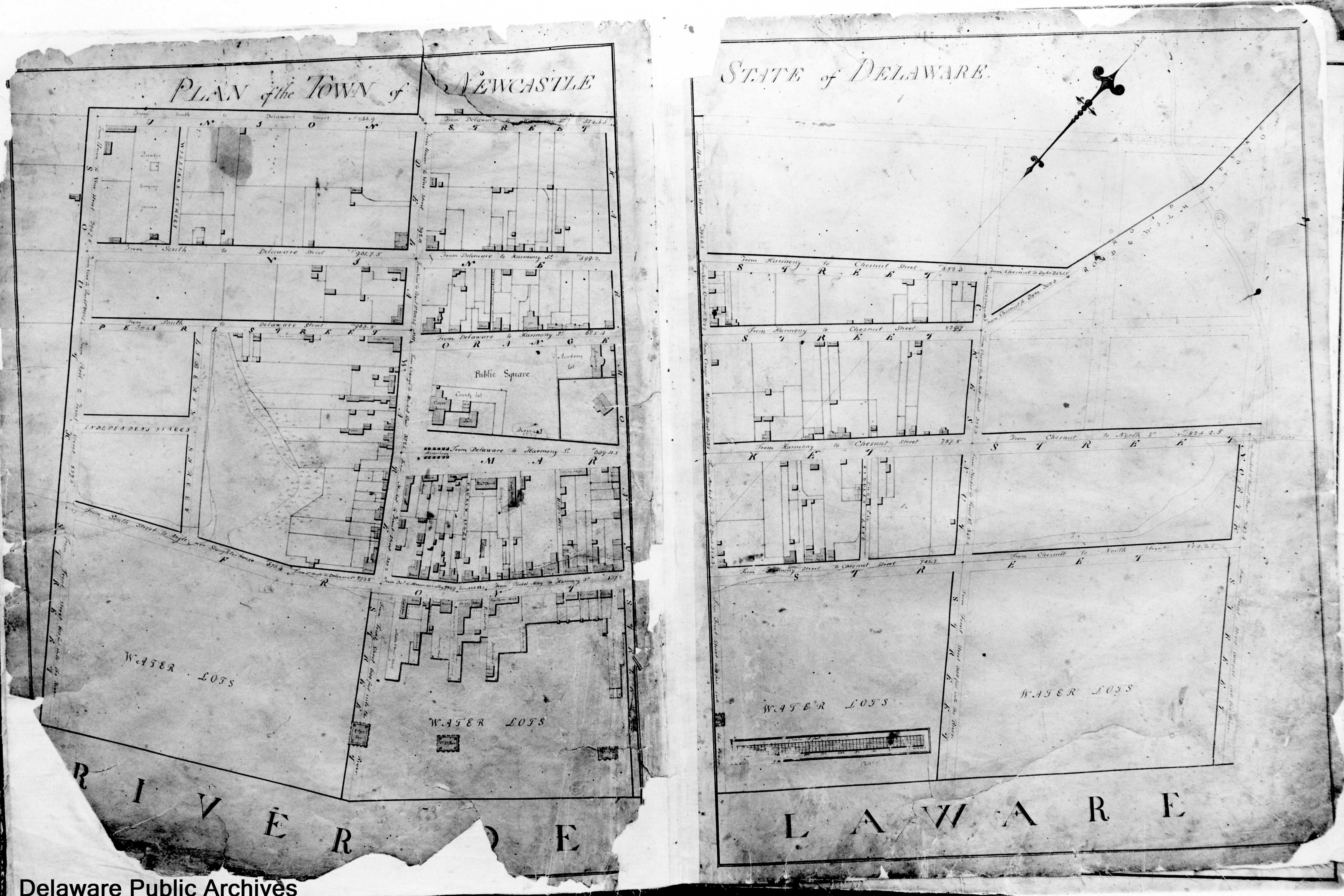
New Castle, Delaware: Comparison of Maps from 1805 & 2005
Application of Geographic Information System
Tools to the Latrobe Survey
of New Castle
The Survey of Newcastle made by Benjamin Latrobe and assistants in 1805 is historically important because it is a record of where buildings stood, and in some cases how they looked, prior to a fire in 1824 that destroyed many houses. Copies of the survey have appeared in many books. But to allow comparison of it with modern maps using modern GIS tools, a digitized version is needed. Files are available here for black and white versions of the whole map, a map of the waterfront area in color pieced together from slides in the archives, elevations of the main streets and GIS georeferenced images.
![]()
There are two original copies of the survey. A first draft is at the New Castle Historical Society. The copy submitted to the town fathers is in the Delaware Public Archives, Dover. Digital scanning of a black and white version of the Dover copy at 600 dpi provides images that clearly show house locations, but most of the annotations of property owners and building use are illegible. The copy in Dover is in color. All of the Front Street image, but only portions of the plan are available in color.
I took the scanned version of the survey, cleaned it up digitally with a photo editor and overlayed it onto New Castle County tax maps and infrared aerial photos using ArcGIS software. The result allow some interesting comparisons of changes in the town over 200 years. The lot lines from the Latrobe Survey are white, those from the tax parcel map are red.
|

|
Click on the images to enlarge them.
| WATERFRONT The biggest change
is in the location of the shoreline. In 1805, the whole waterfront
of the first block of Front Street (now The Strand) consisted of
wharves. Since then, the waterfront has shifted about 200 feet into
the river. The "ice piers" built in 1802 to protect the wooden
hulled ships from ice damage in winter lay where there is now
land. The subsequently built ice piers are much further
out in the river. |

|
| FIRE DAMAGE A fire that started on a windy day in 1824 behind the Riddle (Jefferson) house destroyed many houses on Front Street. The 1805 survey therefore provides us a look not only at the elevations (see available files), but also the exact location of what existed at the turn of the 19th century. The map to the right shows only Front Street and the outline of houses in the survey. The overlay here is based only on surviving houses on this street. Many of the rebuilt houses were changed in style and size. |  |
MARKET AREA The courthouse and
academy buildings still stand on the Green,  but the 12 market houses were replaced by the Town Hall.
The jail and work house were replaced by the Sheriff's
house. but the 12 market houses were replaced by the Town Hall.
The jail and work house were replaced by the Sheriff's
house. The Immanuel Church (built 1703, enlarged 1820 and rebuilt after a fire in 1980) seems to have a different orientation in the survey from that shown in the photo. The georeferencing of the images needs further work. Note that in the view to the right, Reed's alley runs through the  George Reed II house. George Reed II house. |

|
| WATER LOTS When the Dutch layed out
New
Amstel in the 1650's, the lots on the river (the Water Lots, as
opposed to the "Bank Lots" and inland lots) were 600 feet deep.
Owners had the rights to build wharves along the waterline, and petition
to build docks into the river. [Correct????]. The lots and
rights carried over when the English took over in 1664. The
lots for .. to .. The Strand are still 600 feet deep!
STREET LAYOUT A comparison of the 2005
tax parcel map with the survey shows that the layout and dimensions of the
streets in the area covered by the plan is essentially unchanged.
The greatest deviations appear to be near Market street. A few
streets shown on the survey (North, Liberty, Independence) do not now
exist. A few streets (Shaw and Foundry) have been added in the
area. Streets on the east and north edges of town that were proposed
but not yet built by 1805 were never built. |

|
 ALLEYS Church Alley has
been totally relocated eastward. The
location of Packet Alley is unchanged, although what appears to be stairs
leading into the water have disappeared. ALLEYS Church Alley has
been totally relocated eastward. The
location of Packet Alley is unchanged, although what appears to be stairs
leading into the water have disappeared. |
|
BULL HILL The Broad Dyke
Canal is now much broader and runs directly into the Delaware River.
The dimensions of the dyke itself seem not to have changed much. The
stream appeared to be much narrower in the survey, and curved around and
to merge into Front Street. The exact location of the waterline in
the second block of Front Street is not shown on the survey. Sixty
years later in the
Beer's atlas, water appears to come right up to the
street. |

|
 A QUAKER BURYING GROUND and meeting
house is shown in the northwest corner of town.
Currently, the Bethany church is in that area, with graves dating back to
late 1800's But the survey shows that the burying ground lies west
of Williams Street, not east as is the Bethany church. The overlay
shows the site of the meeting house as underneath the
firehouse. The burying ground lies underneath the back yards of
69 and 71 W 5th street. A QUAKER BURYING GROUND and meeting
house is shown in the northwest corner of town.
Currently, the Bethany church is in that area, with graves dating back to
late 1800's But the survey shows that the burying ground lies west
of Williams Street, not east as is the Bethany church. The overlay
shows the site of the meeting house as underneath the
firehouse. The burying ground lies underneath the back yards of
69 and 71 W 5th street. |
 |
Data files are available
Benjamin Henry Latrobe and his students Robert Mills and William Strickland surveyed New Castle, Delaware in 1804-1805. The survey was to help the newly formed local government plan the town's development and to plan the re-grading of the streets to improve drainage. The surveyors became famous architects. Among the buildings they designed are the Treasury building, Washington Navy Yard, Washington Monument, a portion of the US Capitol, the Philadelphia Waterworks, Bank of Pennsylvania and Baltimore Cathedral.
For questions or comments, my email address at verizon.net is james.l.meek (printed this way to make life difficult for spam robots). Or call me at (302)-326-1275.
HOME (JLMeek.com)